Earthquake in Kolkata Today (27 February 2026): Complete Analysis for UPSC Aspirants
A significant earthquake shook Kolkata and large parts of West Bengal on 27 February 2026, sending residents rushing out of buildings in panic. This article provides a fact-based, UPSC-oriented deep dive into the event — covering the earthquake data, tectonic causes, India's seismic zonation, disaster management framework, and potential UPSC question angles.
🚨 What Happened? — Key Facts at a Glance
| Parameter | Details |
|---|---|
| Date & Time | 27 February 2026, ~1:30 PM IST |
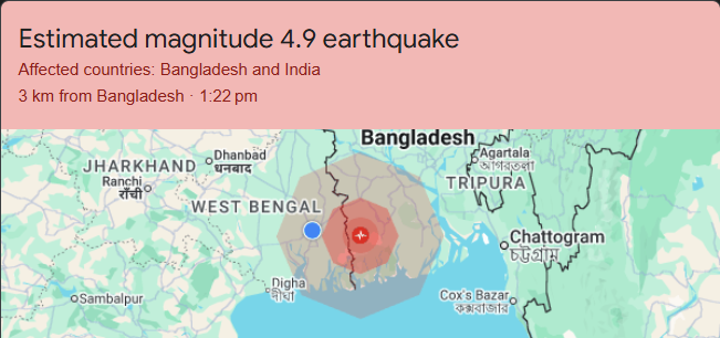
| Magnitude | 5.7 on the Richter Scale (as per DD News/Newsonair); initial reports ranged 4.9–5.6 |
| Epicenter | Near Dhaka, Bangladesh |
| Depth | 10 km (Shallow earthquake) |
| Regions Affected | Kolkata, multiple districts of West Bengal, parts of Bangladesh |
| Casualties/Damage | No immediate reports of casualties or major structural damage |
| Reported By | National Center for Seismology (NCS), DD News, India TV |
⚠️ **Note:** This is a developing story. Magnitude values may be revised as official agencies complete their review. The NCS auto-generated events are later reviewed by seismologists.
Districts of West Bengal including Kolkata felt a jolt of an earthquake around 1:30 PM on 27 February 2026. The epicenter has been reported near Dhaka, Bangladesh, at a depth of 10 km, and the magnitude was 5.7 on the Richter scale. District correspondents reported that people felt tremors across the region. Initial reports from India TV indicated the magnitude as 4.9, while the headline was later updated to mention 5.6 magnitude — such variations are normal in breaking seismic events.
🌍 Why Did Kolkata Feel This Earthquake? — The Science Explained Simply
1. Shallow Depth = Stronger Shaking
This earthquake occurred at a depth of only 10 km. In seismology, earthquakes at depths less than 70 km are classified as shallow-focus earthquakes. The shallower the earthquake, the more intensely it is felt on the surface.
**UPSC Key Term:** *Shallow-focus earthquakes* cause more surface damage compared to intermediate (70–300 km) or deep-focus (>300 km) earthquakes.
2. Kolkata Sits on Soft Alluvial Sediment
Kolkata is located on the Ganges Delta — a massive pile of soft river sediment. When seismic waves travel through such soft soil, they get amplified — a phenomenon known as site amplification or the basin effect.
🧪 Think of it like this: Shaking a bowl of jelly (soft sediment) vs. shaking a rock (hard bedrock). The jelly wobbles much more!
3. Proximity to the Epicenter
The epicenter was near Dhaka, Bangladesh — roughly 250–300 km from Kolkata. At this distance, a magnitude 5.7 shallow earthquake can easily produce noticeable shaking (MMI III–IV) in a city built on alluvial soil.
🗺️ India's Seismic Zones — Where Does Kolkata Stand?
Understanding India's seismic zonation is essential for UPSC — it appears in both Prelims (Geography) and Mains (Disaster Management / GS-III).
Seismic Zoning Map of India (BIS Classification)
| Seismic Zone | Risk Level | Zone Factor (Z) | MSK Intensity | Key Regions |
|---|---|---|---|---|
| Zone II | Low | 0.10 | VI or less | Bangalore, Hyderabad, Nagpur, parts of South India |
| Zone III | Moderate | 0.16 | VII | Kolkata, Mumbai, Chennai, Lucknow, Ahmedabad |
| Zone IV | High | 0.24 | VIII | Delhi, Srinagar, parts of North India, Patna |
| Zone V | Very High | 0.36 | IX+ | Kashmir Valley, Kutch (Gujarat), NE India, Andaman |
| Zone VI (New – 2025) | Highest | 0.90 | — | Entire Himalayan Arc (J&K to Arunachal Pradesh) |
Key Facts for UPSC
- Kolkata lies in Seismic Zone III, which indicates a moderate risk of earthquakes.
- Although the city is not as prone to severe seismic activity as regions like Northeast India, the Himalayas, or Gujarat, occasional tremors are felt due to nearby seismic events in the Bay of Bengal, Bangladesh, Nepal, or Northeast India.
- The Bureau of Indian Standards (BIS) is the nodal agency that classifies seismic zones.
- Approximately 59% of India's landmass (now updated to 61% under the 2025 revision) is vulnerable to earthquakes.
- 75% of India's population now lives in seismically active regions.
🆕 2025 Update: India's New Seismic Zonation Map
In late 2025, India released a revised Seismic Zonation Map under the updated Earthquake Design Code (BIS, 2025):
| Feature | Old Map (2002) | New Map (2025) |
|---|---|---|
| Number of Zones | 4 (Zone II to V) | 5 (Zone II to VI) |
| Himalayan Classification | Split across Zone IV & V | Single highest-risk Zone VI |
| Methodology | Deterministic (historical) | Probabilistic (PSHA) |
| Land area at risk | 59% | 61% |
| Boundary towns | Classified in lower zone | Automatically placed in higher zone |
📝 **UPSC Relevance:** The introduction of **Zone VI** and the shift to **Probabilistic Seismic Hazard Assessment (PSHA)** is a significant current affairs topic for GS-I (Geography) and GS-III (Disaster Management).
🔬 Tectonic Context: Why Is This Region Seismically Active?
The Indian Plate Story
The Indian Plate is driving into the Eurasian Plate at a rate of approximately 47 mm/year. This collision is responsible for:
- The formation of the Himalayas
- Intense seismic activity along the Himalayan Frontal Thrust (HFT)
- Stress transmission into the Indo-Gangetic Plain and Bengal Basin
Key Fault Systems Near Kolkata & Bangladesh
| Fault / Feature | Relevance |
|---|---|
| Dauki Fault | Runs along the Bangladesh-Meghalaya border; major source of seismic risk for Bengal Basin |
| Eocene Hinge Zone | Runs through Bengal; separates the stable Indian Shield from the deep Bengal Basin sediments |
| Sagaing Fault (Myanmar) | Responsible for multiple earthquakes felt in this region, including the devastating M7.7 quake of March 2025 |
| Plate Boundary Zone | The India-Burma plate boundary runs through Myanmar, generating frequent seismic activity felt in Bangladesh & eastern India |
Recent Seismic Activity Near Kolkata (2025–2026)
| Date | Magnitude | Epicenter | Depth |
|---|---|---|---|
| 27 Feb 2026 | 5.7 | Near Dhaka, Bangladesh | 10 km |
| 26 Feb 2026 | 4.8 | Gyalshing, Sikkim | 10 km |
| 25 Feb 2026 | 5.1 | Myanmar | 129 km |
| 03 Feb 2026 | 5.8–6.0 | Akyab, Myanmar | 56–57 km |
| 03 Feb 2026 | 4.1 | Satkhira, Bangladesh | 150 km |
| 21 Nov 2025 | 5.4 | Near Dhaka, Bangladesh | Shallow |
| 28 Mar 2025 | 7.7 | Mandalay, Myanmar | — |
This region has been experiencing **elevated seismic activity**, which experts link to **stress readjustments** following the devastating **M7.7 Myanmar earthquake of March 2025**.
🏛️ Disaster Management Framework in India — UPSC GS-III
Institutional Framework
| Institution | Role |
|---|---|
| NDMA (National Disaster Management Authority) | Policy-making, guidelines, and national plans for disaster management |
| SDMA (State Disaster Management Authority) | State-level disaster planning and implementation |
| NCS (National Centre for Seismology) | 24/7 earthquake monitoring, seismic network operation, early warning |
| BIS (Bureau of Indian Standards) | Seismic zonation map, earthquake-resistant building codes |
| BMTPC | Promotes disaster-resistant construction technologies |
| NDRF (National Disaster Response Force) | Specialized response force for disaster situations |
Key Legislation
- Disaster Management Act, 2005 — The umbrella legislation governing disaster management in India
- National Policy on Disaster Management, 2009 — Aims to build a safer and disaster-resilient India
- IS 1893 (Part 1) — BIS code for earthquake-resistant design of structures
NDMA Guidelines for Earthquake Preparedness
- Building codes enforcement — Structures must follow BIS earthquake-resistant design codes
- Seismic microzonation — Detailed mapping of cities with population above 5 lakh
- Retrofitting — Strengthening existing buildings in high-risk zones
- Public awareness — Regular awareness campaigns through print, electronic, and social media
- Early warning systems — Development of earthquake early warning networks
📖 Important Terminology for UPSC
| Term | Simple Meaning |
|---|---|
| Epicenter | The point on the Earth's surface directly above the focus — first to experience seismic waves |
| Focus / Hypocenter | The actual point below the surface where the earthquake energy originates |
| Richter Scale | Measures magnitude (energy released); logarithmic scale |
| Mercalli Scale (MMI) | Measures intensity (how strongly shaking is felt); based on observation |
| Seismograph | Instrument used to detect and record earthquakes |
| P-Waves | Primary waves — fastest, travel through solids & liquids, compressional |
| S-Waves | Secondary waves — slower, travel only through solids, transverse |
| Liquefaction | Soil behaves like liquid during earthquake (high risk in alluvial zones like Kolkata) |
| PSHA | Probabilistic Seismic Hazard Assessment — modern scientific method for hazard estimation |
| Site Amplification | Soft soil amplifies seismic waves, increasing damage potential |
✍️ Probable UPSC Questions from This Topic
Prelims-Style MCQ
Q: Kolkata falls under which seismic zone of India?
- (a) Zone II
- (b) Zone III ✅
- (c) Zone IV
- (d) Zone V
Q: The 2025 revised seismic zonation map of India introduced which new highest-risk zone?
- (a) Zone V-A
- (b) Zone VII
- (c) Zone VI ✅
- (d) Zone V+
Mains-Style Questions
- "Discuss the seismic vulnerability of the Bengal Basin with reference to recent earthquakes felt in Kolkata. Suggest measures for earthquake preparedness in Zone III cities." (250 words, 15 marks)
- "Critically analyze the significance of the 2025 revised Seismic Zonation Map of India. How does the shift from deterministic to probabilistic methodology improve disaster risk reduction?" (250 words, 15 marks)
- "What is liquefaction? Why are cities built on alluvial plains particularly vulnerable to earthquake damage?" (150 words, 10 marks)
🔑 Key Takeaways for Quick Revision
| # | Takeaway |
|---|---|
| 1 | Earthquake of M5.7 struck near Dhaka, Bangladesh on 27 Feb 2026; tremors felt strongly in Kolkata & West Bengal |
| 2 | Epicenter depth was 10 km (shallow) — shallow earthquakes cause stronger surface shaking |
| 3 | Kolkata lies in Seismic Zone III (Moderate Risk) under BIS classification |
| 4 | Kolkata's alluvial soil (Ganges Delta) amplifies seismic waves — site amplification effect |
| 5 | India's 2025 revised seismic map added Zone VI for the Himalayan arc; now uses PSHA methodology |
| 6 | 61% of India's landmass and 75% of its population are in seismically active regions |
| 7 | Key nodal agencies: NDMA, NCS, BIS, NDRF, BMTPC |
| 8 | The region has seen elevated seismic activity since the M7.7 Myanmar earthquake (March 2025) |
| 9 | Disaster Management Act, 2005 is the key legislation |
| 10 | Indian Plate moves into Eurasian Plate at ~47 mm/year — root cause of Himalayan & regional seismicity |
📚 Sources & References
- DD News / Newsonair (Government of India) — Official earthquake reporting
- India TV News — Breaking news updates
- National Centre for Seismology (NCS), Ministry of Earth Sciences
- Bureau of Indian Standards (BIS) — Seismic Zonation Code IS 1893
- European-Mediterranean Seismological Centre (EMSC)
- USGS (United States Geological Survey)
- Bangladesh Meteorological Department (BMD)
- Vision IAS, Maps for UPSC — Seismic Zone Analysis
- Wikipedia — Earthquake Zones of India; 2025 Bangladesh Earthquake